
_________________________
Esteban Zamora
Architect
+56 9 45 69 29 90
esteban.zamora@gmail.com
Hernán Cortés 2501 | Ñuñoa
www.regeneraxion.org
Santiago | Chile
_________________________
_________________________
Esteban Zamora
Architect
+56 9 45 69 29 90
esteban.zamora@gmail.com
Hernán Cortés 2501 | Ñuñoa
www.regeneraxion.org
Santiago | Chile
_________________________
URBATONE
Esteban ZAMORA, Marc DE FOUQUET , Amin BELMAHI et Emilie BARTOLO
Europan 12 - La Ville adaptable
Concours
Paris Saclay - France 2013


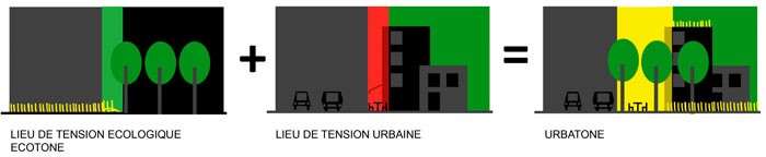
“An ecotone is a transition area between two biomes. It is where two communities meet and integrate. It may be narrow or wide, and it may be local (the zone between a field and forest) or regional (the transition between forest and grassland ecosystems).
An ecotone may appear on the ground as a gradual blending of the two communities across a broad area, or it may manifest itself as a sharp boundary line.
The word ecotone was coined from a combination of eco(logy) plus -tone, from the Greek tonos or tension – in other words, a place where ecologies are in tension.(…) Because an ecotone is the zone in which two communities integrate, many different forms of life have to live together and compete for space. Therefore, an ecotone can create a diverse ecosystem.”
Land crop freezing is currently debated in France and in the European Union. But public institutions have not as yet dealt with the question of natural spaces. Nevertheless city dwellers are eager for more access to nature in the city. Those spaces are richer in biodiversity than their cultivated areas counterparts. The dilemma remains in the fact that economic value cannot be applied to those spaces untill the link between living conditions and natural space is established. It is therefore hard for designers to find a way to value them. In the near future, those spaces could be the one to enable the city to adapt to the challenge of social changes.
Natural ecosystem can adapt to human activity. That capacity, rather than being considered
as an obstacle should be used as a tool in the planning process. To achieve that goal, town planning has to find means to integrate ecological functions. Urban ecosystem can rise from that inversion.

The city was built around the Yvette river, in the valley, the East-West axis is the structuring element to transports. Still intercity networks are saturated and there is little prospect of developing city crossing. Bus travels are also limited, considering the road width in the old town center of Bures and Orsay, not to mention the fact that they represent an important source of nuisance.
The campus is set over half of the valley but is not connected to the network. The calm atmosphere, necessary to studying resulting from that secluded location is perceived by some as a feeling of profound boredom, more over in the holiday time Even if often discussed, the developing project of Saclay cluster doesn’t include any new means of transport a part from the existing bus line.The steep slope landscape makes the implementation of a motorized system pretty difficult. The walk alongside the Yvette river is the only cycle route linking Bures to Orsay. The towns are planning to create a cycle route on the route de Chartres towards Gometz, but the width may not be sufficient to accommodate this connection between Bures and Orsay. On the campus site there are quite a few informal walking connection points that are not exploited. Light development work on those green paths could easily
open up the site.

GREEN GRID
The campus landscape is dominated by the presence of trees and forest, some natural spaces are inaccessible. Numerous wetlands are set along the river Yvette and its surroundings are subject to groundwater. Various green species of all kinds are represented. Thanks to nearby scientists and botanists many rare plants have been identified (eg Bois d’Orsay orchid).

BOTANIC PARK
The campus represents a green space not always domestic but connected with the parks and public gardens of Bures-sur-yvette and Orsay (parc du château de la Grande Maison, bois de la Guyonnerie, parc du Launay).
In Orsay, the De Launay botanic park is defined by the university boundary.
It is home to natural spaces, the walk alongside the river Yvette, but also to the section dedicated to research such as fruit trees or green houses. We could say that the university buildings are actually well embedded in the park. In the north garden areas are sometimes used as allotment by the adjoinging. While the university entry and exit are clearly defined, the park entrance is not really perceptible. The park is a place of mixed uses without clearly defined boundaries. It could easily spread over the whole perimeter of Bures-sur-Yvette.


The site is strongly defined by a natural setting over an area prone to flooding. Still that very nature welcomes mixed uses which are segmented in time and space.
The site is not well connected and poorly linked to nearby urban city centers. While preserving it from 20th century urbanism, the site secluded components also prevent it from playing an expected dynamic role in the valley.
The site attractiveness resides in its very little or not urbanized nature and its proximity with the developing urban city centers. How could we then consider an intervention that will adapt to those qualities without losing its long term adaptability?

URBAN PLANNING ADAPTATION TO SITE ECOLOGICAL CONDITIONS
Site analysis shows the overwhelming presence of green areas on the campus. The projet’s aim is to find the necessary conditions to preserve the presence of nature into urban areas: which is the site’s future. That priority outweights the site’s challenges because it attempts to suppress the fundamental contradiction between a densification willingness and the preservation of nature into the city as wished by the city dwellers. Our urban principle consists in sparing, for all new infrastructures and constructions, the necessary conditions to the setting of an urban and ecological tension area, the Urbatone.
This principle declined at city level and on the ecology will allow the structuring of urban landscape and will give it an adaptation ability to city dwellers’ practices and bio diversity. Thus, for every change of environment, development will be adjusted as to amplify ecological and urban dynamic,
URBAN PLANNING ADAPTATION TO TERRITORY EVOLUTION
Even though the Orsay University campus is part of the cluster project led by the National Interest Operation Paris-Saclay, the strategic challenges are centered over the Saclay plateau. The university, historical place for scientific research, has to adapt to that new situation. Through our proposition, the campus will become a « rotula » creating an articulation between the new plateau area and the towns of Bures-sur-yvette and Orsay, distinct environment meant to be complementary. By proposing a different and innovative offer with new equipments that will fulfill the university’s new needs we are offering attractive activities for the residents of Bures-sur-Yvette, Orsay, as well as for the residents of the new densified campus. The new plan does not claim to compete with the existing urban fabric of the old city centers, nor does it claim to compete with the new plateau de Saclay projet. Our projet aims at bringing a complement fulfilling its role within the scientific cluster or Paris-Saclay.
URBAN PLANNING ADAPTATION TO SITE INFRASTRUCTURES
When the site is strongly linked to ecological grids, it still misses relations with the urban structure upon which it depends. It is yet very well inclined to welcome major infrastructures.The challenges developed by the Saclay scientific cluster project imply the creation of a link between the RER B and the plateau which preserves the site. The extremely strong constrain of the difference in height orientated the project towards the setting of a cable railway between the Bures-sur-Yvette station and Saclay via the campus center. Transport services need to be reinforced due to the dimension of the site. Besides the location of the station at the heart of the campus embodies political will to bring the different competence centers closer together. On the other hand, access to the plateau will be reinforced by two supplementary railway connections via the hillsides. One of them will highlight the entrance of the site to the north and connect to the Pierre de Coubertin axis to the south new entrance (work in progress). The north axis is thus highlighted. It is treated just like all the other new transport network, and thus supports ecological functions. The adding of the new direct connection to the RER in the town of Orsay and the requalification of existing informal entrances opens the door to the Orsay campus. The river Yvette is a place of east-west geographical connection, and also a north-south boundary. The blue infrastructure will be used as a strong link to the valley. The Yvette walk starting at Villebon-sur-Yvette makes the connection, on campus site, between the Chateau de la Grande maison’s park (in Bures-sur-Yvette) and the setting of the park du Launay and the Guyonnerie wood. Its surroundings are usable as such, but the walk has very few connections with the campus. The building of that ecotone including footbridges, rest area and observation spots will guaranty the opening of the walk upon the river and its surroundings. Finally, the adding of the city farm and the Forum will enhance its attraction.
Those infrastructure settings, over the landscape or the ecology, such as the cable railway in Bures, the access to Orsay, the ecotones and the city farm, the walk on the river Yvette will enable to address the Paris-Saclay site from the valley and will open the campus.


SITE ADAPTATION TO INFRASTRUCTURES
Infrastructures are necessary to connect to the urban fabric, but residents are often affected by them. In the present situation the existing connection network is of a good size and there is enough space to cater for its surroundings. Those roads like the new ones will host the urban ecotones, they represent an important potential of good quality living environment. We will adapt the project and exiting network in accordance with the area it crosses so as to separate the flow, and set the living spaces further away from the noisy uses which could create meeting spaces. (CF. Plan Urbatones). The landscape treatment will also be different according to the sections. It will incorporate rainwater treatment and reduction of air pollution. The university halls are now in need of refurbishment, just like the transport network they can play a hybrid role to enhance their use. The Forum with a gym Hall and n°220 could suggest the start to a university without tabula rasa.
SITE ADAPTATION TO NEW BUILDING PROGRAMS
The STAPS training ground is presently underused even though it is one of the rare facilities to become lively during the week-ends when it hosts sports competitions. As the city wishes to develop a housing program over the stadium site, we will move the municipal stadium around the STAPS as well as all the programs included in and around the gym Hall (to be transformed into FORUM and housing).
The putting together of sites between state schools, and universities activities will increase the facilities capacity and will enable to foresee the building of an Olympic type stadium. The short distance to the cable railway makes it a new center of gravity at the heart of the project.
The sports facilities are thus grouped together and orientated towards the whole of the community. Sport people of all levels will gather there at different time schedule. In order to link that new center pole to the existing urban fabric, we will connect it by footbridges over the Yvette river. Access will then take place alongside a fitness trail set in nature, that will offer daily practice opportunities.
NATURAL SPACES ADAPTATION TO NEW PROGRAMS
Every natural surface can mute to a principle of agroforestry. But some of the plots are bound to facilitate, in relation with the university, agricultural experimental production of cereals, market gardening or pharmacological product. The project therefore puts into synergy the local practices existing for a long time over the territory (agriculture and experiment) in relation to their surroundings (flooding area, grassland, wood). The city farm perfectly illustrates that operating. The integration of that program into the town will develop an agricultural awearness over the whole of the site. First we think that the agroforestry spaces will be used by the university itself, then with the arriving of the new residents, the principle will be spread to forest gardening at short distance from their housing. Finally providing an economic balance sets itself we can think that concessions will be allocated to farmers.


ADAPTATION OF BIODIVERSITY TO URBAN STRUCTURE
Urban structure is a source of biodiversity. Urban development originate new uses of space that inevitably modify original ecosystems. Those changes when dealt with over a long time period can actually generate biodiversity and can lead to the creation of new uses. In a shorter time period, natural spaces and urban ecotones will evolve with the passing of seasons in shape terms, but our program will enable them to evolve in terms of uses as well.
CONSERVATION OF SITE ADAPTATION ABILITY
Free plot of land are the key to the city’s development. They are only seen by planners as free spaces, but actually detain better sources of adaptation ability to future uses than the built environment. They are the source that we will draw upon today in order to develop tomorrow.
On site, natural spaces are treated so as to be usable by humans in the future. Urban development method consists in giving them evolvement capacity, in differentiating them and in proposing a new use for the community. Park, agroforestry, forest garden, city farm and research.
Ecotone generated by urban planning of natural sites will evolve in time and space to enable the city to adapt to new needs.
CONSERVATION OF THE ADAPTATION ABILITY TO ACADEMIC CHALLENGES
The project integrates the presence of the university into the building process. Nevertheless many mixed uses tend to open up the site. In the first place, those uses will increase the time frame in which site facilities are used. In case of a relocation of the university, the development of an urban park will be possible, with agricultural uses totally separated from the campus. Housing will then be adapted to the new mix of population arriving on site.

Natural ecosystem can adjust to human settlement. Rather than resisting it, that ability should be taken into account and integrated into the development concept. To achieve that, we need to find means to create an urban organization that integrates ecological functions. The notion of ecotone is diverted when working with biomimetism. It becomes the support for urban and architectural adaptation. It makes it possible for the site to mutate in good conditions towards new functions of contemporary way of life. From that intention will the urban ecosystem urban rise.
